Cross-Border Pipeline Construction: China Risk Series
Share article



Geoffrey Craig, Senior Product Strategist
This article is the third in a series that explores how satellite-based analytics can effectively monitor China’s energy sector for signs of military preparations.
In the event of a US-led naval blockade or embargo, where would China turn for oil imports if tankers could not arrive?
This question is significant when you consider the vital role that oil plays in both military and economic terms, especially for an oil import-dependent country like China, which relies heavily on seaborne imports.
The only other option is cross-border pipelines, though a significant effort would be required to increase the capacity to even partly offset the loss of seaborne imports. Additionally, pipelines aren’t quick to complete.
It is reasonable to conclude that China would take steps to expand existing pipelines or build new ones in advance of any military action that could provoke the naval response described above.
Testifying at a Congressional hearing, one expert said that cross-border pipeline construction could be considered one of several warning signals of China’s intent to mobilize its military for war.
Fortunately, there is a way to monitor pipeline construction using satellite imagery, which will be discussed below. But first, let’s review China’s current infrastructure.
There are three pipelines that deliver crude oil to China from neighboring countries, as shown in the map below.
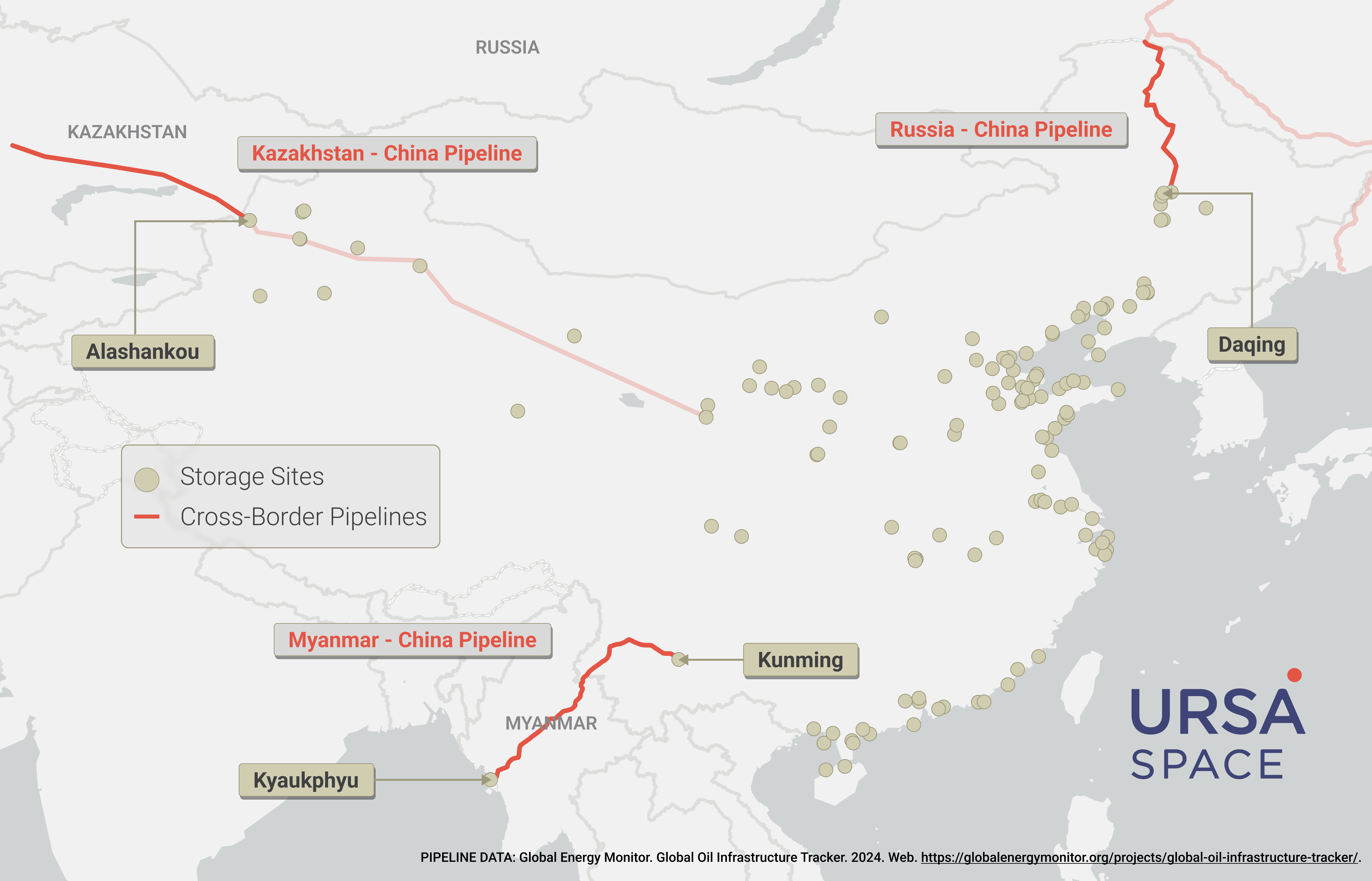
The Myanmar-China pipeline runs from the Indian Ocean port of Kyaukphyu to a refinery in China near the capital of Yunnan Province, Kunming.
The Kazakhstan-China pipeline delivers oil from Central Asia to Alashankou, a border town. From there, oil travels through a trunk pipeline that traverses western and central China. Domestic production augments the supply along the way, with pipeline connections to refineries.
The Russia-China pipeline is a branch of the East Siberia-Pacific Ocean (ESPO) pipeline that terminates in Daqing, in northeastern China. There are connections between Daqing and the major cities and economic zones around the rim of the Bohai Sea.
If China were to expand an existing cross-border pipeline or build a new one, the construction would likely not be carried out with complete transparency. How would you know what’s happening?
Satellite-based approach
Ursa Space can automatically identify the physical changes that occur at a specific location to detect and quantify changes to the physical landscape.
This solution utilizes synthetic aperture radar (SAR), a satellite-borne sensor that operates in any weather, day or night, combined with Ursa Space’s proprietary algorithms.
To illustrate this technique, we can look at the example of the Baltic Pipe, a natural gas pipeline connecting Norway with Poland and Denmark, which became operational in 2022.
We tracked the pipeline’s construction over a two-year period starting in September 2020 by applying a change detection algorithm on SAR imagery.
The results can be visualized in kernel density heat maps. These maps highlight higher values based on clustering and their measured area in square meters. Brighter areas indicate both a clustering of change points and larger areas of change.
Below is a closer look at the section where the pipeline comes onshore in Denmark.

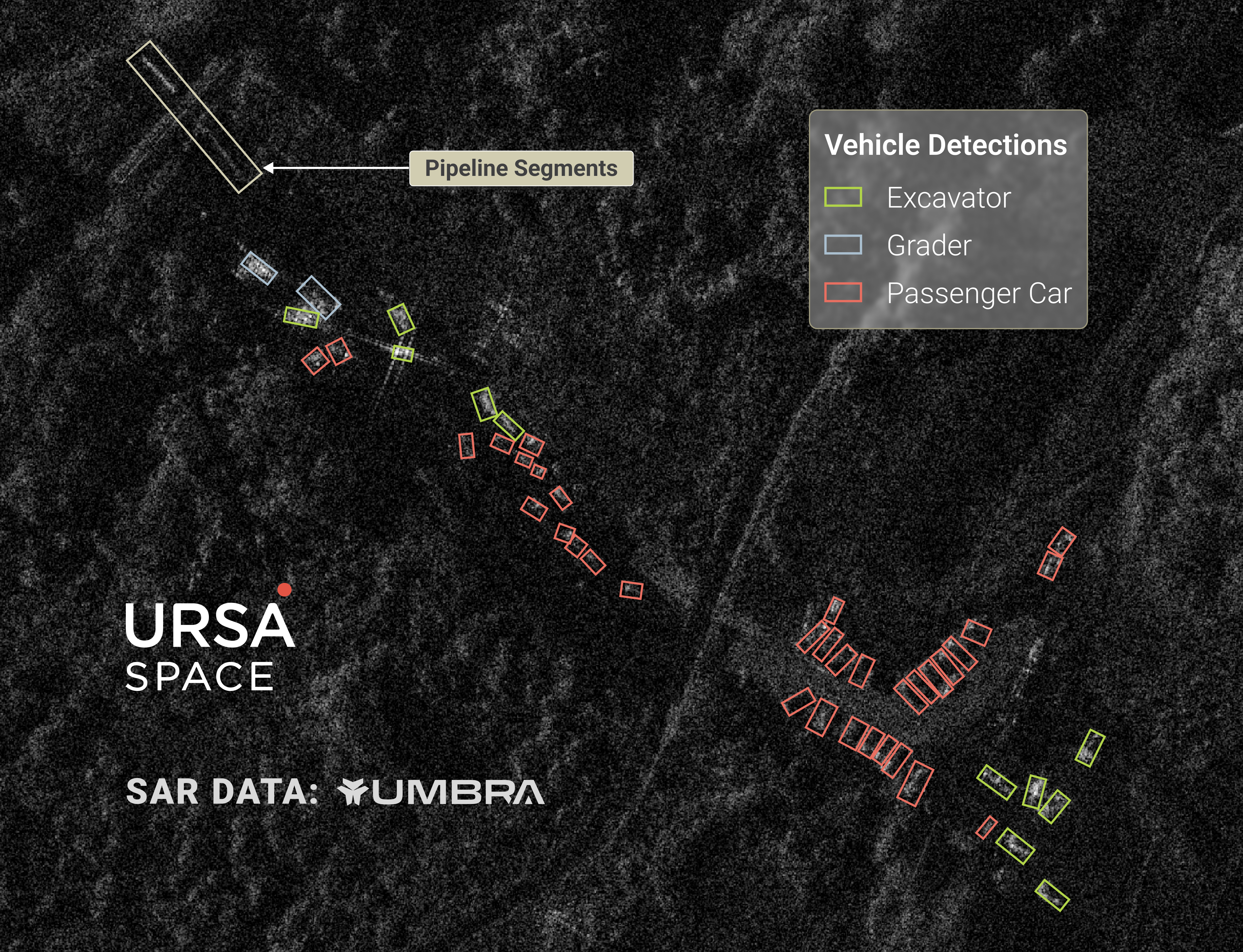
For a more granular view, a slightly different technique can be used, by applying Ursa Space’s proprietary object detection algorithms on SAR imagery.
The example below shows a section of a new pipeline being built. We have automatically identified different pieces of equipment, specifically 11 excavators, 2 graders and 34 vehicles. The pipeline segments are sitting in the northwest corner of the staging area.
Even with increased pipeline supplies, it’s unrealistic to expect China to replace the lost seaborne imports entirely.
Additional measures, such as demand rationing (i.e., lowering refinery run rates), could help mitigate the shortfall. However, each passing day would further deplete the country's stockpile, bringing it one step closer to running out of oil.
This makes it all the more important for China to bulk up inventories as much as possible beforehand, similar to having an emergency fund in case of a job loss.
Next, we will return to the topic of oil storage, discussing the role of below-ground facilities in China’s stockpile strategy.
Share article
